
Project
OSCE Geographic Information System (OGIS)

Quick links
- Project period:
- 03/2024 - 03/2026
- Implemented by:
- OSCE Secretariat
Overview
The OSCE Geographic Information System (OGIS) Pilot Project is a landmark initiative launched in 2024 to transform how the Organization for Security and Co-operation in Europe collects, manages, and utilizes geospatial data. Implemented jointly by the Conflict Prevention Centre/Operations Service and the Department of Management and Finance/Information and Communication Technology Services , the project supports eight pilot users across Secretariat departments and field operations.
OGIS empowers OSCE executive structures with tailor-made GIS applications to enhance situational awareness, planning, operational efficiency, and data-driven reporting. By integrating spatial data into programmatic workflows—from human security to environmental monitoring—the platform strengthens the OSCE’s capacity to respond to evolving regional challenges. The project serves as a scalable model for potential organization-wide GIS integration.
OSCE Geographic Information System (OGIS)
To visit the official project page of OSCE Geographic Information System (OGIS):
About OGIS
The OSCE Geographic Information System (OGIS) is a flagship digital transformation initiative aimed at enhancing how the Organization for Security and Co-operation in Europe (OSCE) leverages geospatial data in its operations, planning, and reporting.
Launched in 2024, OGIS responds to the growing demand for structured, visualized, and interactive spatial information across OSCE executive structures. The initiative is implemented jointly by the Conflict Prevention Centre / Operations Service and the Department of Management and Finance / Information and Communication Technology Services, with technical leadership from the Secretariat’s two Geographic Information Officers.
OGIS delivers a secure, web-based GIS platform built on open standards, capable of hosting multiple thematic applications tailored to operational needs. Through the pilot phase, the system serves eight OSCE units and field presences, addressing use cases such as:
- Real-time security incident visualization
- Fleet tracking and management
- Human trafficking mapping and analysis
- Environmental and energy security monitoring
The project was preceded by a comprehensive feasibility study (2022–2023) and formally launched in March 2024. A structured needs assessment, delivered in spring 2024, identified core business areas and user requirements, laying the groundwork for targeted application development.
OGIS aligns with the OSCE’s strategic goals of digital modernization, operational agility, and improved situational awareness. The platform serves not only as a technical solution, but also as a catalyst for institutional knowledge-sharing, capacity building, and integrated data governance across missions and departments.
The pilot project provides a scalable model for organization-wide geospatial integration, supporting the OSCE’s comprehensive approach to security in an increasingly data-driven world.
OGIS Pilot Use Cases
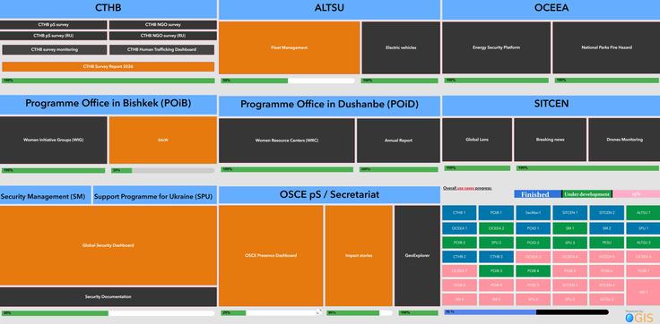
Colorful organizational chart with blue, orange, green, and black sections displaying labeled departments and programs.
OGIS directly supports eight pilot user groups across the OSCE, each with unique operational needs. Through a robust needs assessment process and Agile development practices, tailored GIS applications are being designed, developed, and deployed to solve real-world challenges.
Featured Use Cases
- SitRoom (Conflict Prevention Centre)
Real-time incident mapping, alerting, and trend analysis for early warning and operational coordination. - Security Management (SM)
Integration of the Everbridge Safety Alert System and security dashboards for tracking incidents affecting staff. - Asset, Logistics and Travel Support Unit (ALTSU)
Fleet composition, utilization analytics, and electrification planning through vehicle tracking dashboards. - Support Programme for Ukraine (SPU)
Programme dashboards for managing activities, tracking outputs, and conducting geo-referenced assessments. - Programme Office in Bishkek (POiB)
Interactive mapping of gender-based violence data, small arms control, and Persons with Disabilities emergency planning. - Programme Office in Dushanbe (POiD)
Story maps and dashboards for Women’s Resource Centres and victim support service coordination. - Office of the Special Representative and Co-ordinator for Combating Trafficking in Human Beings (O/CTHB)
Open-source data integration and dashboards for tracking anti-trafficking interventions. - Office of the Co-ordinator of OSCE Economic and Environmental Activities (OCEEA)
Energy security, container tracking, climate monitoring, and water management dashboards, including support for Ukraine–Moldova transboundary water cooperation.
Impact and Benefits

OGIS enables the OSCE to:
- Modernize legacy workflows across departments
- Improve real-time situational awareness and early warning
- Communicate results visually with internal and external stakeholders
- Enhance asset tracking and operational planning
- Support programmatic work with geo-tagged evidence
- Foster knowledge-sharing and interoperability across field operations
OGIS also aligns with:
- OSCE ICT Strategy (2020–2023)
- UN Sustainable Development Goals:
- SDG 5 (Gender Equality)
- SDG 9 (Innovation)
- SDG 16 (Peace, Justice & Institutions)
Partners
Project Lead Units
- Conflict Prevention Centre / Operations Service (CPC/OS)
- Department of Management and Finance / Information and Communication Technology Services (DMF/ICTS)
Pilot Users
- SitRoom (Situation Room)
- Security Management
- ALTSU (Asset, Logistics and Travel Support Unit)